The Archer Stone
Prehistoric sandstone menhir with Early Bronze Age cup and ring markings, also known as Robin Hood's Stone.
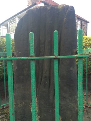
In the heart of suburbia, enclosed by green painted iron railings, lies an ancient sandstone menhir. A weathered bronze plaque within the railings explains the stone’s recent history:
“THIS MONOLITH KNOWN AS “ROBIN HOODS STONE” STOOD IN A FIELD NAMED THE STONE HEY AT A SPOT 198 FEET DISTANT, AND IN A DIRECTION BEARING 7 DEGREES EAST OF TRUE NORTH FROM ITS PRESENT POSITION, TO WHICH IT WAS MOVED IN AUGUST 1928.”
The monolith is known as “The Archer’s Stone” on account of a series of deep grooves worn into it, once believed to have been used during medieval times for sharpening arrowheads. The road next to it crosses a field once used by archers for practice. This practice was actually made law in the 16thC.
As fanciful as this idea might seem, it is perhaps worth mentioning that during the 19th century the common consensus amongst antiquarians was that these grooves were created by Druids to aid the draining of blood from their sacrificial victims. They weren’t.
The grooves are now generally considered to have occurred naturally when the rock was formed and been further ingrained as the fragile sandstone was worn away by aeons of wind and rain. Archerfield Road is so named because it was built upon the site of the field where The Archer’s Stone once stood – the construction of that neighbourhood being the reason for the stone’s relocation in the 1920s.
Although the supposed arrow sharpening/bloodletting grooves are now considered to be natural, there are other, more intriguing, markings on Robin Hood’s Stone which are currently buried beneath a thick layer of concrete. A 1910 photograph of the now hidden end of the menhir clearly shows cup and ring markings thought to date from the Early Bronze Age, very similar to some of the markings on the nearby Calderstones in Calderstones Park.
The photograph was taken by R. Stuart-Brown and published, along with at least one other of Robin Hood’s Stone, in his 1911 work A History of the Manor and Township of Allerton in the County of Lancashire, Liverpool. This other photograph shows the stone standing in its field with roughly the same portion of its surface underground as today – the cup and rings still very much hidden from view. Only when the earth was dug out around the base of the menhir were the ancient carvings made visible.
Know Before You Go
At the junction of Archerfield Road and Booker Avenue. Liverpool.


Follow us on Twitter to get the latest on the world's hidden wonders.
Like us on Facebook to get the latest on the world's hidden wonders.
Follow us on Twitter Like us on Facebook