19th-Century Atlases Included Hundreds of Fake Islands
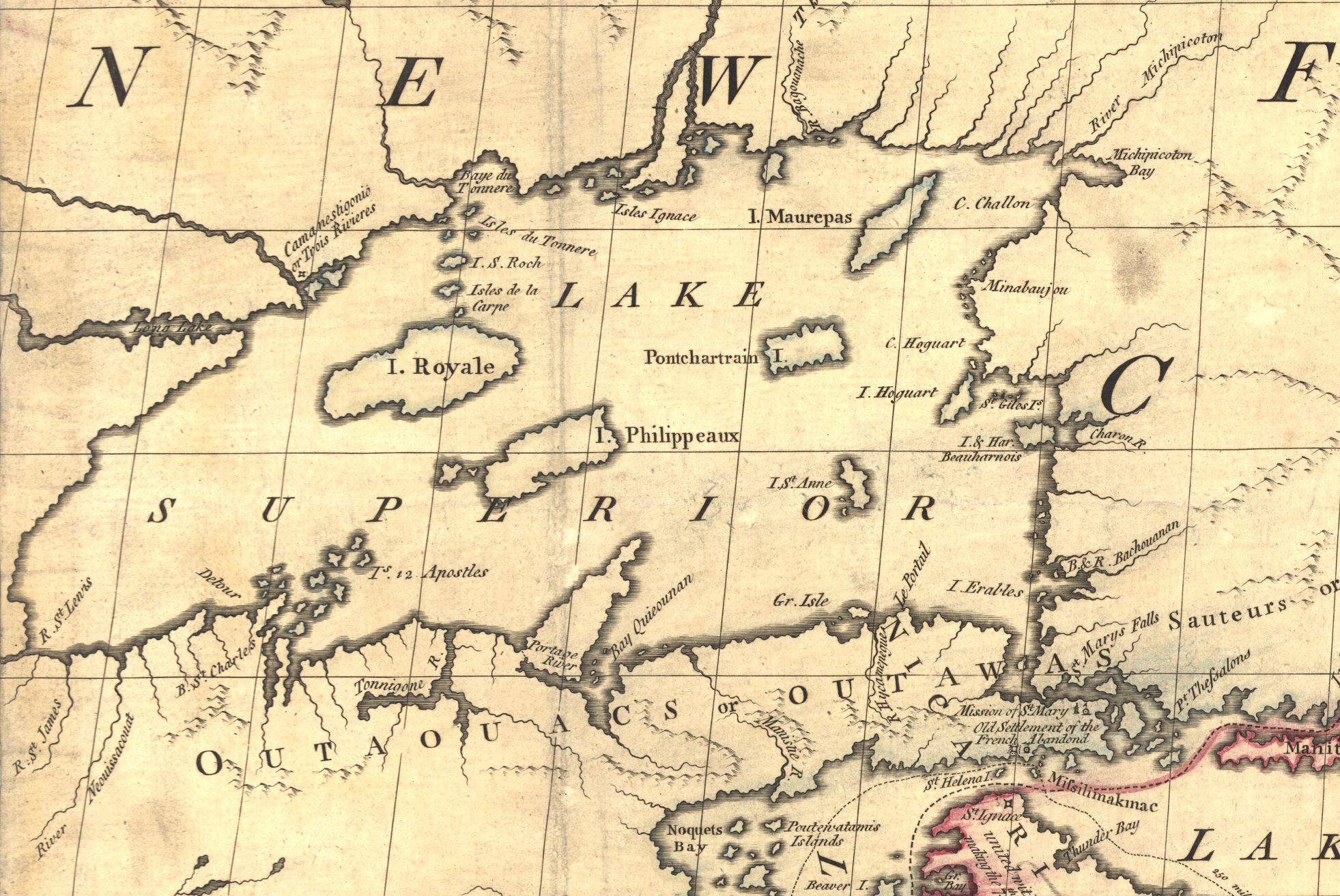
An 18th century British map with some made-up islands in Lake Superior (Image: Wikimedia)
In 1913, a small group of explorers set sail from New York and headed towards Greenland. They were looking to solve what Donald MacMillan, the head of the expedition, called “the last great geographical problem of the North.” They were planning to explore Crocker Land.
Seven years before, in the summer of 1906, Robert Peary, an American explorer aiming to reach the North Pole, was standing on Cape Thomas Hubbard, on the lookout for a previously unknown piece of land. A tidal expert had predicted it would be somewhere in this vicinity, and, scanning the horizon, he saw it through his binoculars: “the snow-clad summits of the distant land in the northwest above the ice horizon.” He named it after “the late George Crocker,” who had helped finance the expedition.
Peary never reached that island. And neither did MacMillan. There was one main challenge to exploring Crocker Land, MacMillan discovered: it did not actually exist.
Non-existent islands were a surprisingly common problem in the 19th century. Some of them may have once been actual islands, which later sunk beneath the waters. Some of them were genuine mistakes–icebergs misidentified as islands, islands whose longitudes were miscalculated, illusions that really did look like they might be land. Some were straight-up fabricated by sea captains looking to curry favor with funders.
The accumulation of these frauds, errors and mislaid hopes, though, meant that by the end of the 1800s, there were 200 or so islands marked in charts and atlases that just did not exist.
There were Los Jardins, two islands near the Marshalls that Spanish explorers were supposed to have visited in the 16th century. There were islands like Buss, Emerald, and Dougherty, that were likely just fog and ice that polar explorers mistook for actual land. There were the Royal Company Islands, reported to be located southwest of Tasmania, and included on maps for years after it was conclusively proven they did not exist. Phantom islands weren’t even all located in oceans: Isle Phelipeaux and Isle Pontchartrain were supposed to be in the middle of Lake Superior.
There were also Morrell and Byers Islands, the existence of which was reported by Benjamin Morrell, an American captain notorious for overdramatizing his adventures, in 1825. He gave plenty of details about the islands: Byers’ Island, according to Morrell, was “moderately elevated, and has some bushes and spots of vegetation” and was “about four miles in circumference.” Morrell Island was “a small, low island,” also four miles in circumference. Neither actually existed. Byers was a funder of Morrell’s; his other made-up island he named for himself.

The Royal Company Islands (top left corner) do not exist (Image: 1915 German map/Wikimedia)
By the mid-19th century, the proliferation of nonexistent islands was becoming a serious problem for cartographers. In Britain, the Royal Navy’s charts were cluttered with false reports, and, in particular, the 1864 edition of Admiralty Chart 2683, which mapped the Pacific Ocean, was full of mistakes. For the 1875 edition, Sir Frederick Evans, who had spent years surveying waterways and oceans, cut 123 islands from the map, including three that actually existed.
Even that purge did not make world maps accurate, though. Morrell Island slipped through, for instance. As recently as 2012, Sandy Island, which was supposed to be east of Australia, was shown not to exist.
There may still be phantom islands out there, haunting maps. Often, it’s not clear that islands are fake until someone like Donald MacMillan decides to try to find them.





Follow us on Twitter to get the latest on the world's hidden wonders.
Like us on Facebook to get the latest on the world's hidden wonders.
Follow us on Twitter Like us on Facebook