The Mysteries of a Rare, 18th-Century Native American Map
It may have been more about social and trade relationships than geography.

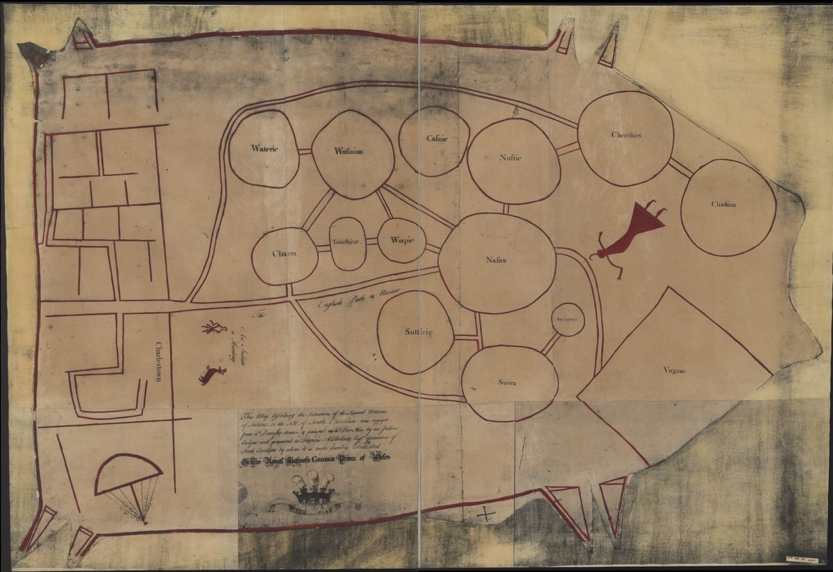
Sometime in the early 1720s, a Native American man went to Charleston and gave Francis Nicholson, then colonial governor of South Carolina, a map inked on deerskin. It depicted geographic and social relationships among the Native American nations in the surrounding area. Squares represent European settlements, with Charleston at one end and Virginia at the other, and circles in between represent Native American communities, connected by double lines that resemble paths.
This map, now known as the “Catawba Deerskin Map,” is one of the only examples of a map created by a Native American and given to Europeans. Colonial settlers reported that native tribes regularly made maps—etched in ash or on tree bark—and that this local cartographic knowledge helped the settlers develop their own maps of areas they wanted to occupy. There are fewer European reports, though, of native people making maps on animal skin or other long-lasting materials. Few maps made by Native Americans survive at all.
This particular example combined geography with information about the relations between people living in the area, and some scholars argue that the paths drawn between the communities represent social and political distance, rather than geography. “This was a map that was meant to illustrate a trade relationship,” Max Edelson, a historian at University of Virginia, told BackStory radio. Edelson’s new book, A New Map of Empire, explains that the center of the map is the Catawba community of Nasaw, and Edelson compares it to the famous “View of the World From 9th Avenue” map, in which New York City takes on a disproportionate amount of space to represent its inhabitants’ view of the world.
There is some question, though, about who actually made the deerskin map. It’s also sometimes described, without attributing it to any single group of people, as “a map describing the situation of the several Nations of Indians between South Carolina and the Mississippi.” The tribe of the person who presented it to the governor is unknown. Nicholson had invited a headman from each town of each nearby nation to visit him, including Catawba and Cherokee representatives.
Historian Ian Chambers, for instance, has argued that the map is of Cherokee origin. One of the keys to his assertion is the path that runs across the top of the map, which connects the Cherokee directly to Charleston. Trade along this connection, Chambers writes, had been logistically challenging, and a Cherokee leader had once promised a trader that “they would make a new path” to ease the way. The central position of the Catawba communities, in this theory, highlights their position as an obstacle to direct trade between the Cherokee and the British, much like a British map might put the Atlantic Ocean at the center of a map of the North American colonies and the British Isles, the center of power, in one corner.
The authorship of the map, though, will probably always be a mystery. The image above is of a copy on paper, not the original deerskin, which was lost. The map only exists today because Nicholson had two copies made and sent back to London, where they now reside in the British Library and the National Archives.


Follow us on Twitter to get the latest on the world's hidden wonders.
Like us on Facebook to get the latest on the world's hidden wonders.
Follow us on Twitter Like us on Facebook